Worthington’s History Walk
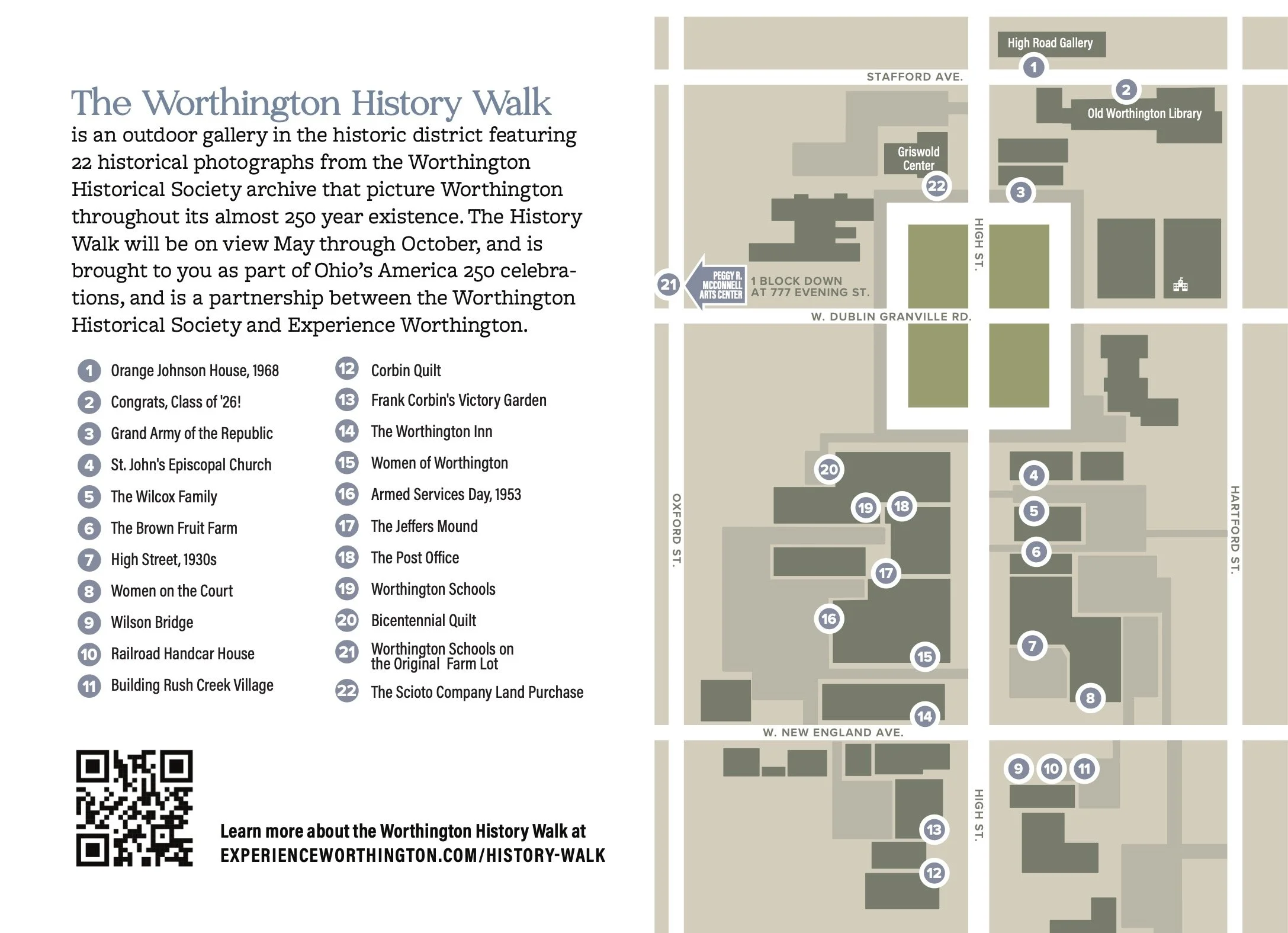
The Worthington History Walk is an outdoor gallery in the historic district featuring 22 historical photographs from the Worthington Historical Society archive that picture Worthington throughout its almost 250 year existence. The History Walk will be on view May through October, and is brought to you as part of Ohio’s America 250 celebrations, and is a partnership between the Worthington Historical Society and Experience Worthington.
SWIPE BELOW TO SEE THE FULL WALK
-
![]()
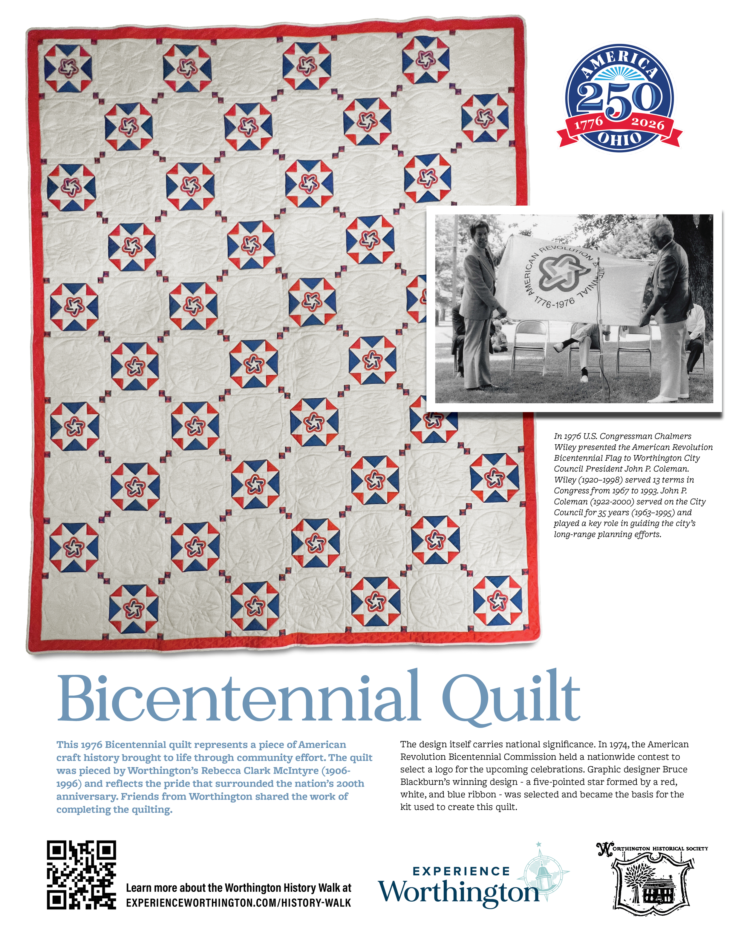
Bicentennial Quilt
This 1976 Bicentennial quilt represents a piece of American craft history brought to life through community effort. The quilt was pieced by Worthington’s Rebecca Clark McIntyre (1906-1996) and reflects the pride that surrounded the nation’s 200th anniversary. Friends from Worthington shared the work of completing the quilting.
The design itself carries national significance. In 1974, the American Revolution Bicentennial Commission held a nationwide contest to select a logo for the upcoming celebrations. Graphic designer Bruce Blackburn’s winning design - a five-pointed star formed by a red, white, and blue ribbon - was selected and became the basis for the kit used to create this quilt.
Inset: U.S. Congressman Chalmers Wiley presents the American Revolution Bicentennial Flag to Worthington City Council President John P. Coleman. Wiley (1920–1998) served 13 terms in Congress from 1967 to 1993. John P. Coleman (1922-200) served on the City Council for 26 years (1970–1996) and played a key role in guiding the city’s long‑range planning efforts.
-
![]()
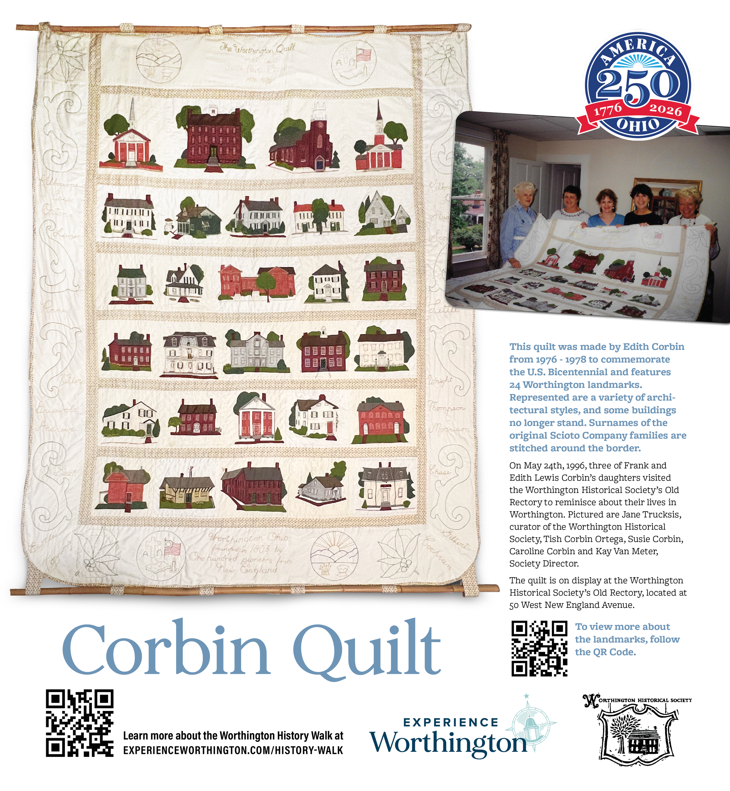
Corbin Quilt
This quilt was made by Edith Corbin from 1976 - 1978 to commemorate the U.S. Bicentennial and features 24 Worthington landmarks. Represented are a variety of architectural styles, and some buildings no longer stand. Surnames of the original Scioto Company families are stitched around the border.
On May 24th, 1996, three of Frank and Edith Lewis Corbin's daughters visited the Worthington Historical Society's Old Rectory to reminisce about their lives in Worthington. Pictured are Jane Trucksis, curator of the Worthington Historical Society, Tish Corbin Ortega, Susie Corbin, Caroline Corbin and Kay Van Meter, Society Director.
The quilt is on display at the Worthington Historical Society’s Old Rectory, located at 50 West New England Avenue.
-
![]()
The Scioto Company Land Purchase
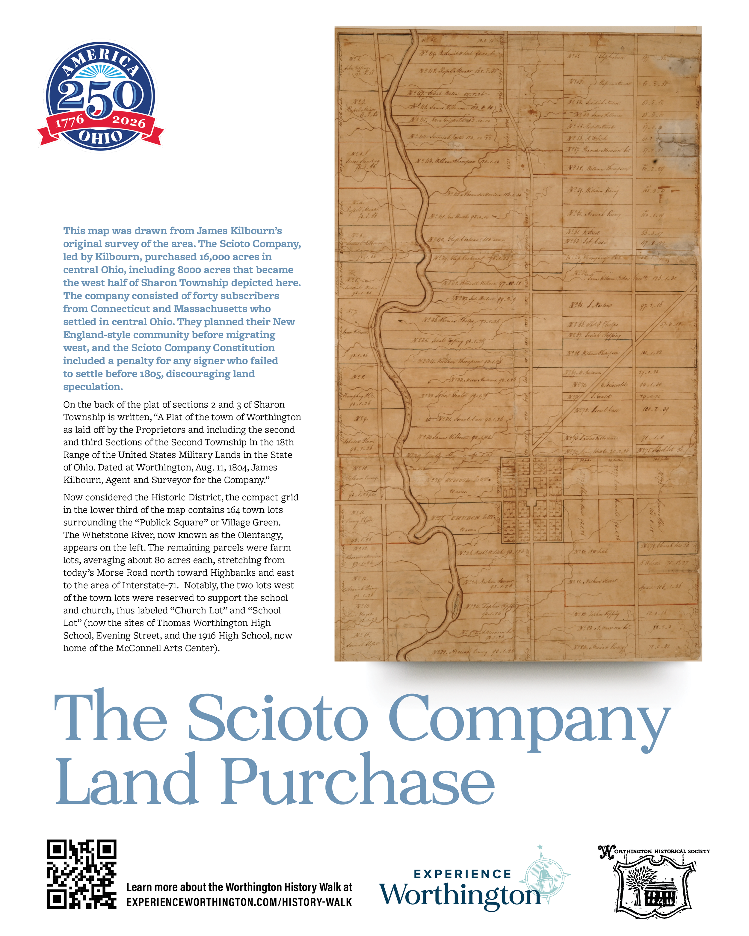
This map was drawn from James Kilbourn’s original survey of the area. The Scioto Company, led by Kilbourn, purchased 16,000 acres in central Ohio, including 8000 acres that became the west half of Sharon Township depicted here. The company consisted of forty subscribers from Connecticut and Massachusetts who settled in central Ohio. They planned their New England-style community before migrating west, and the Scioto Company Constitution included a penalty for any signer who failed to settle before 1805, discouraging land speculation.
On the back of the plat of sections 2 and 3 of Sharon Township is written, “A Plat of the town of Worthington as laid off by the Proprietors and including the second and third Sections of the Second Township in the 18th Range of the United States Military Lands in the State of Ohio. Dated at Worthington, Aug. 11, 1804, James Kilbourn, Agent and Surveyor for the Company.”
Now considered the Historic District, the compact grid in the lower third of the map contains 164 town lots surrounding the “Publick Square” or Village Green. The Whetstone River, now known as the Olentangy, appears on the left. The remaining parcels were farm lots, averaging about 80 acres each, stretching from today’s Morse Road north toward Highbanks and east to the area of Interstate-71. Notably, the two lots west of the town lots were reserved to support the school and church, thus labeled “Church Lot” and “School Lot” (now the sites of Thomas Worthington High School, Evening Street, and the 1916 High School, now home of the McConnell Arts Center).
-
![]()
The Jeffers Mound
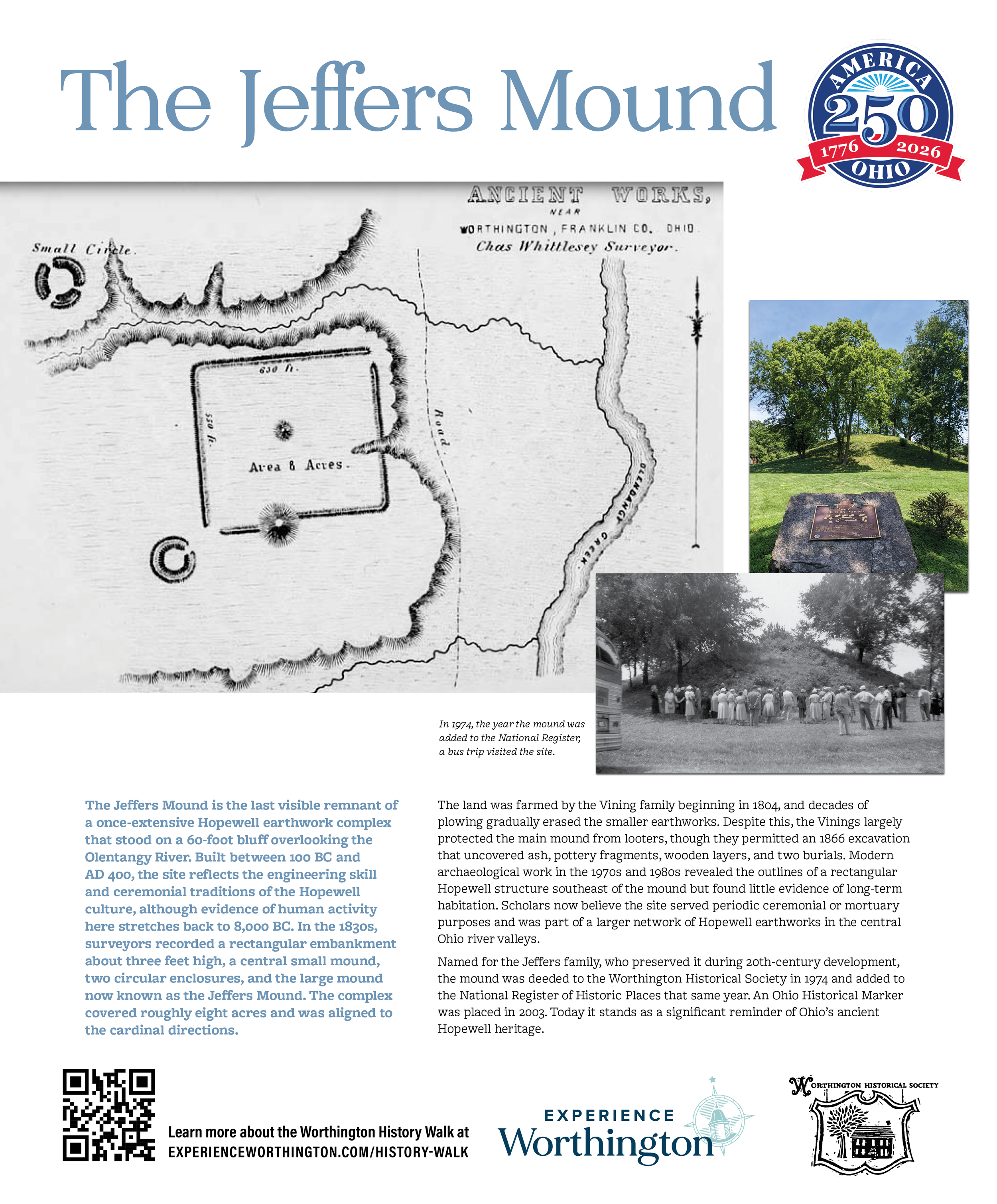
The Jeffers Mound is the last visible remnant of a once‑extensive Hopewell earthwork complex that stood on a 60‑foot bluff overlooking the Olentangy River. Built between 100 BC and AD 400, the site reflects the engineering skill and ceremonial traditions of the Hopewell culture, although evidence of human activity here stretches back to 8,000 BC. In the 1830s, surveyors recorded a rectangular embankment about three feet high, a central small mound, two circular enclosures, and the large mound now known as the Jeffers Mound. The complex covered roughly eight acres and was aligned to the cardinal directions.
The land was farmed by the Vining family beginning in 1804, and decades of plowing gradually erased the smaller earthworks. Despite this, the Vinings largely protected the main mound from looters, though they permitted an 1866 excavation that uncovered ash, pottery fragments, wooden layers, and two burials. Modern archaeological work in the 1970s and 1980s revealed the outlines of a rectangular Hopewell structure southeast of the mound but found little evidence of long‑term habitation. Scholars now believe the site served periodic ceremonial or mortuary purposes and was part of a larger network of Hopewell earthworks in the central Ohio river valleys.
Named for the Jeffers family, who preserved it during 20th‑century development, the mound was deeded to the Worthington Historical Society in 1974 and added to the National Register of Historic Places that same year. An Ohio Historical Marker was placed in 2003. Today it stands as a significant reminder of Ohio’s ancient Hopewell heritage.
-
![]()
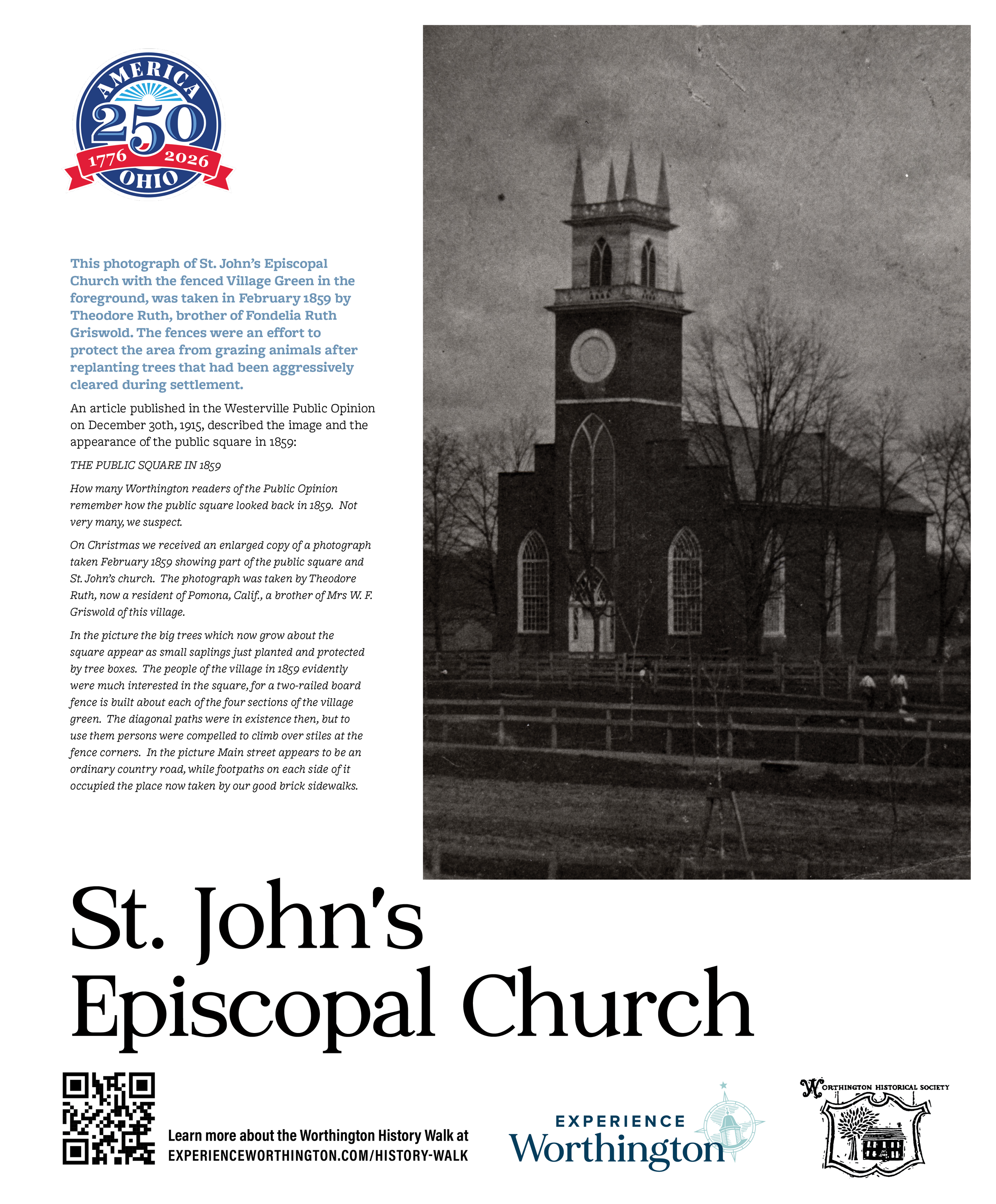
St. John's Episcopal Church
This photograph of St. John's Episcopal Church with the fenced Village Green in the foreground, was taken in February 1859 by Theodore Ruth, brother of Fondelia Ruth Griswold. The fences were an effort to protect the area from grazing animals after replanting trees that had been aggressively cleared during settlement were evident.
An article published in the Westerville Public Opinion on December 30th, 1915, described the image and the appearance of the public square in 1859:
The Public Square in 1859.
How many Worthington readers of the Public Opinion remember how the public square looked back in 1859. Not very many, we suspect.
On Christmas we received an enlarged copy of a photograph taken February 1859 showing part of the public square and St. John's church. The photograph was taken by Theodore Ruth, now a resident of Pomona, Calif., a brother of Mrs W. F. Griswold of this village.
In the picture the big trees which now grow about the square appear as small saplings just planted and protected by tree boxes. The people of the village in 1859 evidently were much interested in the square, for a two-railed board fence is built about each of the four sections of the village green. The diagonal paths were in existence then, but to use them persons were compelled to climb over stiles at the fence corners. In the picture Main street appears to be an ordinary country road, while footpaths on each side of it occupied the place now taken by our good brick sidewalks.
-
![]()
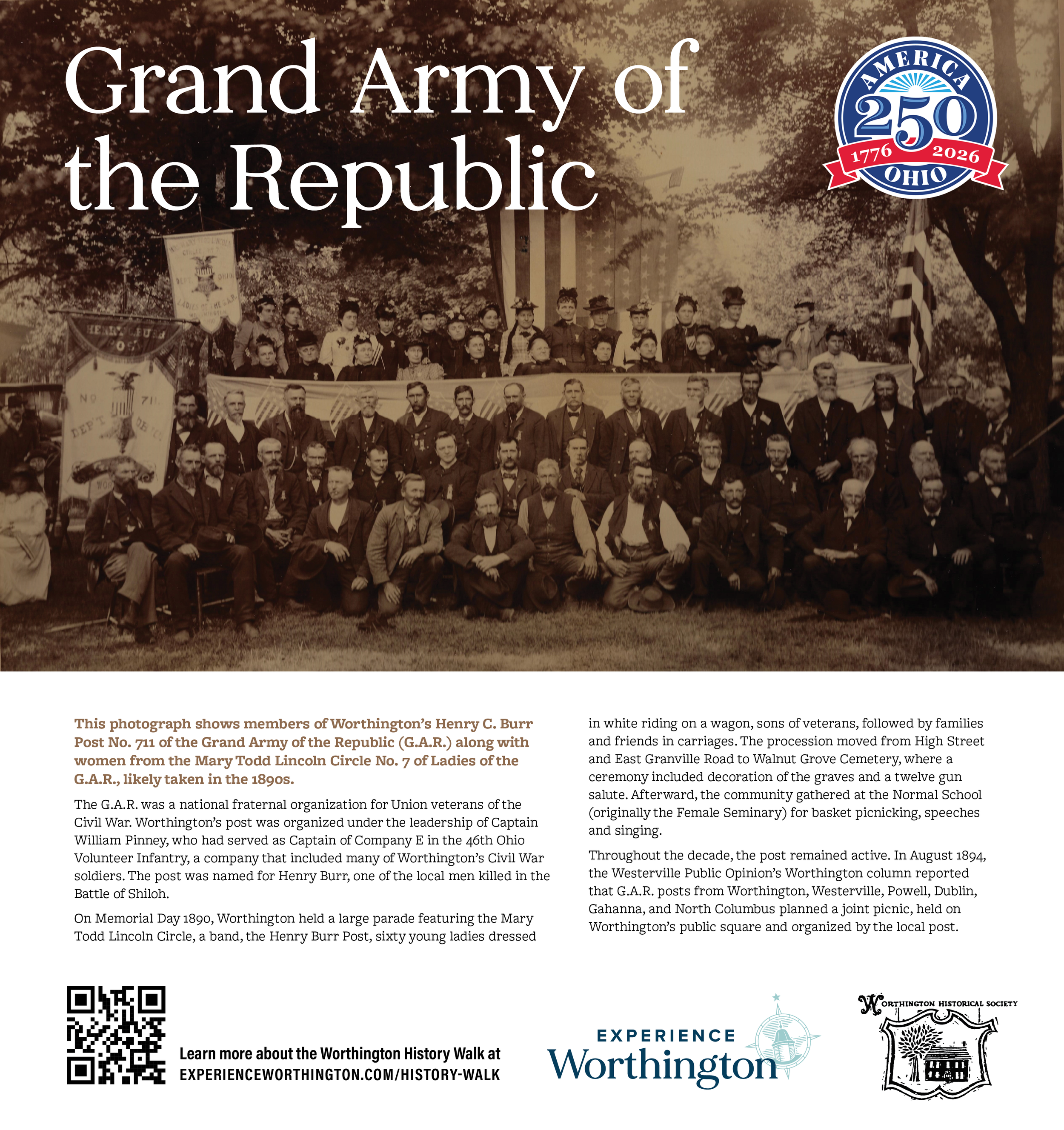
Grand Army of the Republic
This photograph shows members of Worthington’s Henry C. Burr Post No. 711 of the Grand Army of the Republic (G.A.R.) along with women from the Mary Todd Lincoln Circle No. 7 of Ladies of the G.A.R., likely taken in the 1890s.
The G.A.R. was a national fraternal organization for Union veterans of the Civil War. Worthington’s post was organized under the leadership of Captain William Pinney, who had served as Captain of Company E in the 46th Ohio Volunteer Infantry, a company that included many of Worthington’s Civil War soldiers. The post was named for Henry Burr, one of the local men killed in the Battle of Shiloh.
On Memorial Day 1890, Worthington held a large parade featuring the Mary Todd Lincoln Circle, a band, the Henry Burr Post, sixty young ladies dressed in white riding on a wagon, sons of veterans, followed by families and friends in carriages. The procession moved from High Street and East Granville Road to Walnut Grove Cemetery, where a ceremony included decoration of the graves and a twelve gun salute. Afterward, the community gathered at the Normal School (originally the Female Seminary) for basket picnicking, speeches and singing.
Throughout the decade, the post remained active. In August 1894, the Westerville Public Opinion’s Worthington column reported that G.A.R. posts from Worthington, Westerville, Powell, Dublin, Gahanna, and North Columbus planned a joint picnic, held on Worthington's public square and organized by the local post.
-
![]()
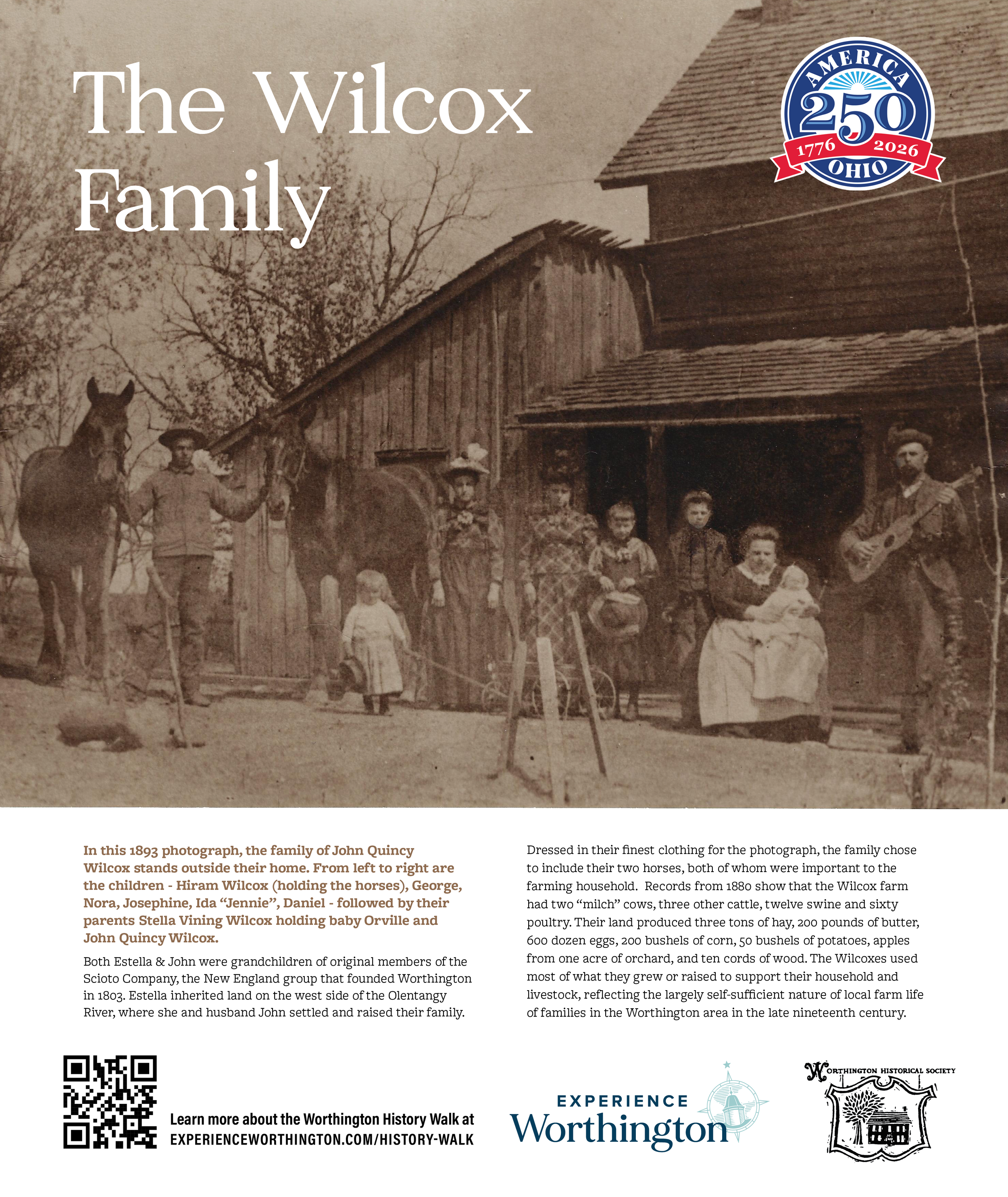
The Wilcox Family
In this 1893 photograph, the family of John Quincy Wilcox stands outside their home. From left to right are the children - Hiram Wilcox (holding the horses), George, Nora, Josephine, Ida "Jennie", Daniel - followed by their parents Stella Vining Wilcox holding baby Orville and John Quincy Wilcox.
Both Estella & John were grandchildren of original members of the Scioto Company, the New England group that founded Worthington in 1803. Estella inherited land on the west side of the Olentangy River, where she and husband John settled and raised their family.
Dressed in their finest clothing for the photograph, the family chose to include their two horses, both of whom were important to the farming household. Records from 1880 show that the Wilcox farm had two “milch” cows, three other cattle, twelve swine and sixty poultry. Their land produced three tons of hay, 200 pounds of butter, 600 dozen eggs, 200 bushels of corn, 50 bushels of potatoes, apples from one acre of orchard, and ten cords of wood, Like many families in the Worthington area, the Wilcoxes used most of what they grew or raised to support their household and livestock, reflecting the largely self-sufficient nature of local farm life of families in the Worthington area in the late nineteenth century.
-
![]()
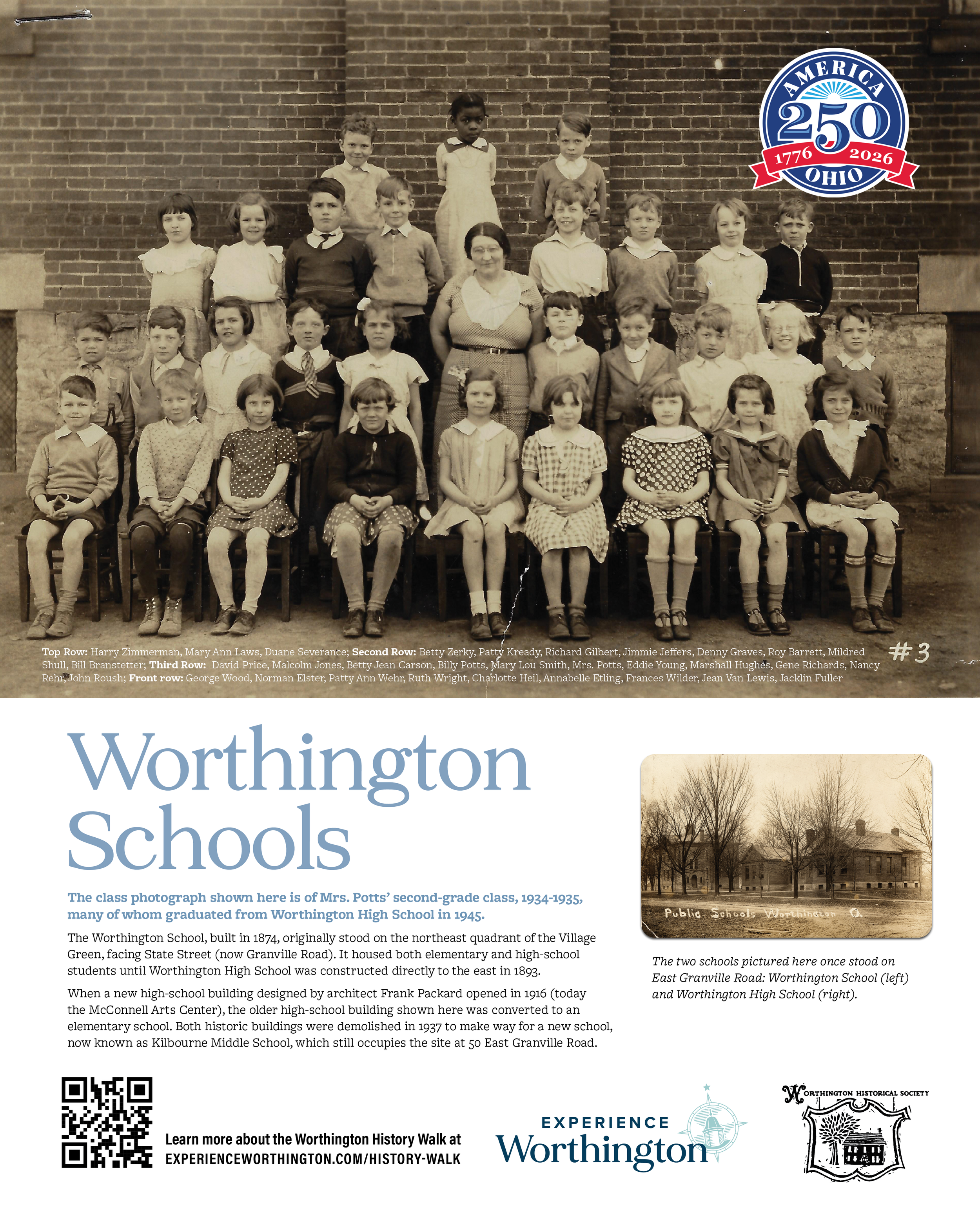
Worthington Schools
The two schools pictured here once stood on East Granville Road: Worthington School (left) and Worthington High School (right). The Worthington School, built in 1874, originally stood on the northeast quadrant of the Village Green, facing State Street (now Granville Road). It housed both elementary and high-school students until Worthington High School was constructed directly to the east in 1893.
When a new high-school building designed by architect Frank Packard opened in 1916 (today the McConnell Arts Center), the older high-school building shown here was converted to an elementary school. Both historic buildings were demolished in 1937 to make way for Kilbourne Middle School, which still occupies the site at 50 East Granville Road.
The class photograph shown here is of Mrs. Potts’ second-grade class, 1934-1935, many of whom graduated from Worthington High School in 1945.
Students pictured:
Top Row: Harry Zimmerman, Mary Ann Laws, Duane Severance;
Second Row: Betty Zerky, Patty Kready, Richard Gilbert, Jimmie Jeffers, Denny Graves, Roy Barrett, Mildred Shull, Bill Branstetter;
Third Row: David Price, Malcolm Jones, Betty Jean Carson, Billy Potts, Mary Lou Smith, Mrs. Potts, Eddie Young, Marshall Hughes, Gene Richards, Nancy Rehr, John Roush;
Front row: George Wood, Norman Elster, Patty Ann Wehr, Ruth Wright, Charlotte Heil, Annabelle Etling, Frances Wilder, Jean Van Lewis, Jacklin Fuller
-
![]()
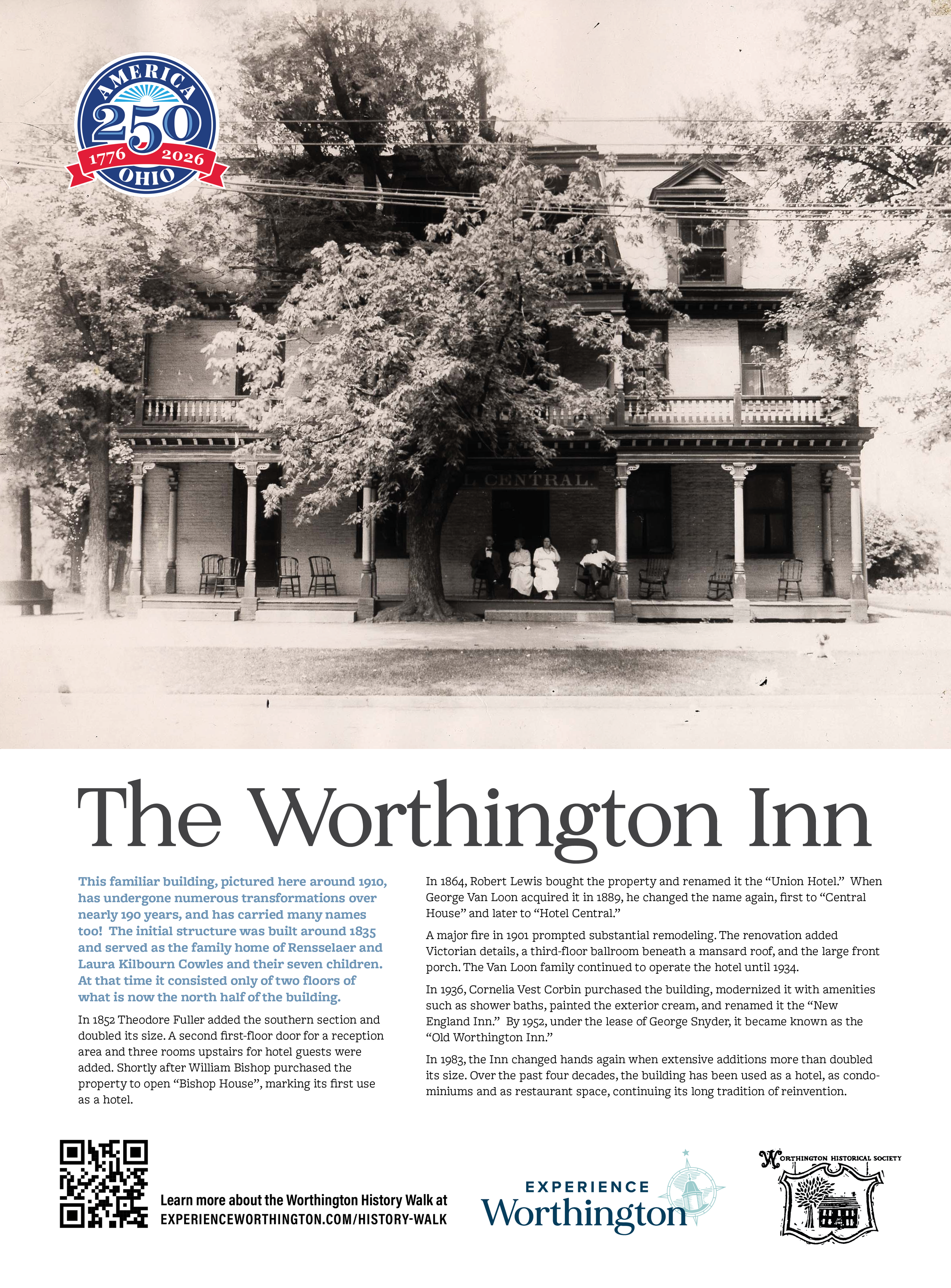
The Worthington Inn
This familiar building, pictured here around 1910, has undergone numerous transformations over nearly 190 years, and has carried many names too! The initial structure was built around 1835 and served as the family home of Rensselaer and Laura Kilbourn Cowles and their seven children. At that time it consisted only of two floors of what is now the north half of the building.
In 1852 Theodore Fuller added the southern section and doubled its size. A second first-floor door for a reception area and three rooms upstairs for hotel guests were added. Shortly after William Bishop purchased the property to open "Bishop House", marking its first use as a hotel.
In 1864, Robert Lewis bought the property and renamed it the “Union Hotel." When George Van Loon acquired it in 1889, he changed the name again, first to "Central House" and later to "Hotel Central."
A major fire in 1901 prompted substantial remodeling. The renovation added Victorian details, a third-floor ballroom beneath a mansard roof, and the large front porch. The Van Loon family continued to operate the hotel until 1934.
In 1936, Cornelia Vest Corbin purchased the building, modernized it with amenities such as shower baths, painted the exterior cream, and renamed it the "New England Inn.” By 1952, under the lease of George Snyder, it became known as the "Old Worthington Inn."
In 1983, the Inn changed hands again when extensive additions more than doubled its size. Over the past four decades, the building has been used as a hotel, as condominiums and as restaurant space, continuing its long tradition of reinvention.
-
![]()
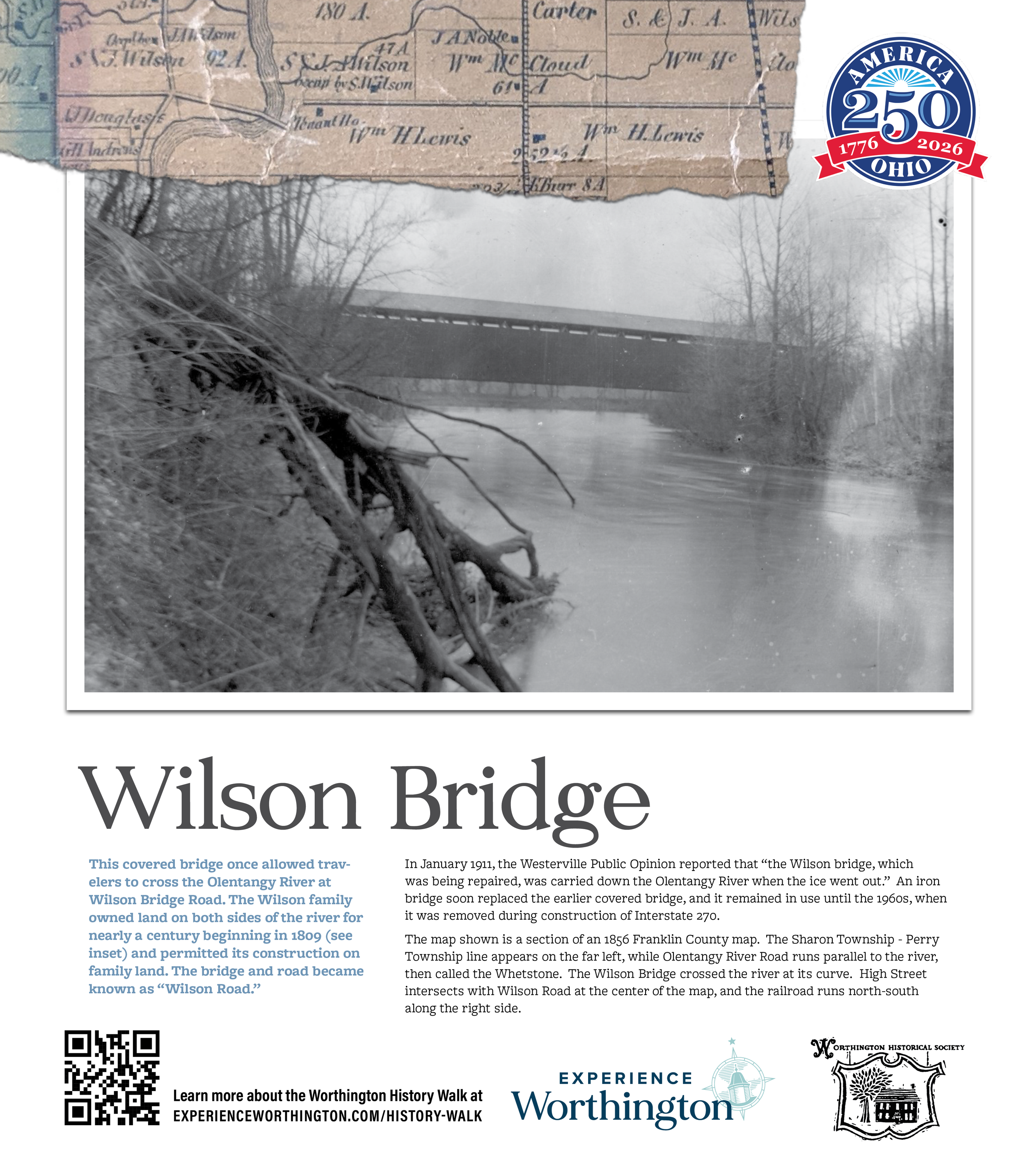
Wilson Bridge
This covered bridge once allowed travelers to cross the Olentangy River at Wilson Bridge Road. The Wilson family owned land on both sides of the river for nearly a century beginning in 1809 (see inset) and permitted its construction on family land. The bridge and road became known as “Wilson Road.”
In January 1911, the Westerville Public Opinion reported that “the Wilson bridge, which was being repaired, was carried down the Olentangy River when the ice went out”. An iron bridge soon replaced the earlier covered bridge, and it remained in use until the 1960s, when it was removed during construction of Interstate 270.
The map shown is a section of an 1856 Franklin County map. The Sharon Township - Perry Township line appears on the far left, while Olentangy River Road runs parallel to the river, then called the Whetstone. The Wilson Bridge crossed the river at its curve. High Street intersects with Wilson Road at the center of the map, and the railroad runs north-south along the right side.
-
![]()
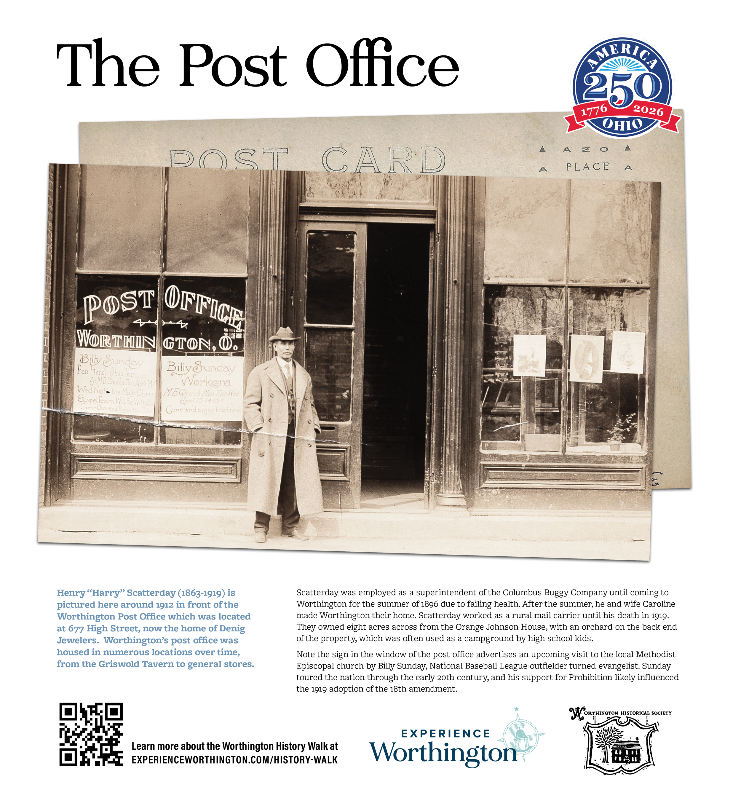
The Post Office
Henry “Harry” Scatterday (1863-1919) is pictured here around 1912 in front of the Worthington Post Office which was located at 677 High Street, now the home of Denig Jewelers. Worthington's post office was housed in numerous locations over time, from the Griswold Tavern to general stores.
Scatterday was employed as a superintendent of the Columbus Buggy Company until coming to Worthington for the summer of 1896 due to failing health. After the summer, he and wife Caroline made Worthington their home. Scatterday worked as a rural mail carrier until his death in 1919. They owned eight acres across from the Orange Johnson House, with an orchard on the back end of the property, which was often used as a campground by high school kids.
Note the sign in the window of the post office advertises an upcoming visit to the local Methodist Episcopal church by Billy Sunday, National Baseball League outfielder turned evangelist. Sunday toured the nation through the early 20th century, and his support for Prohibition likely influenced the 1919 adoption of the 18th amendment.
-
![]()
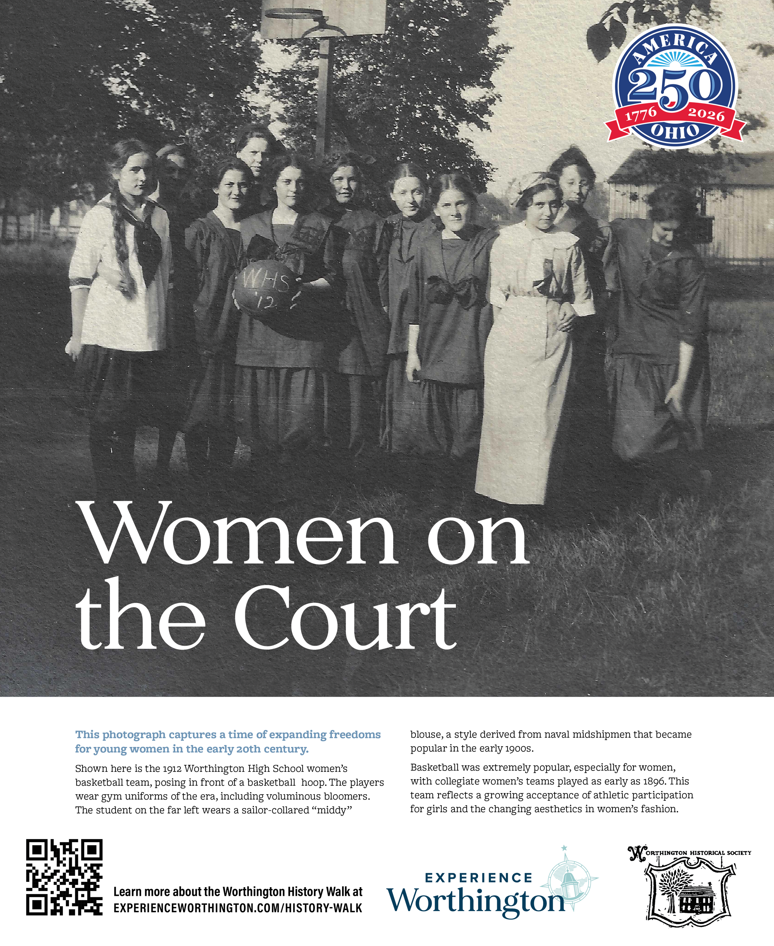
Women On the Court
This photograph captures a time of expanding freedoms for young women in the early 20th century. Shown here is the 1912 Worthington High School women's basketball team, posing in front of a basketball hoop. The players wear gym uniforms of the era, including voluminous bloomers. The student on the far left wears a sailor-collared “middy” blouse, a style derived from naval midshipmen that became popular in the early 1900s.
Basketball was extremely popular, especially for women, with collegiate women's teams played as early as 1896. This team reflects a growing acceptance of athletic participation for girls and the changing aesthetics in women’s fashion.
-
![]()
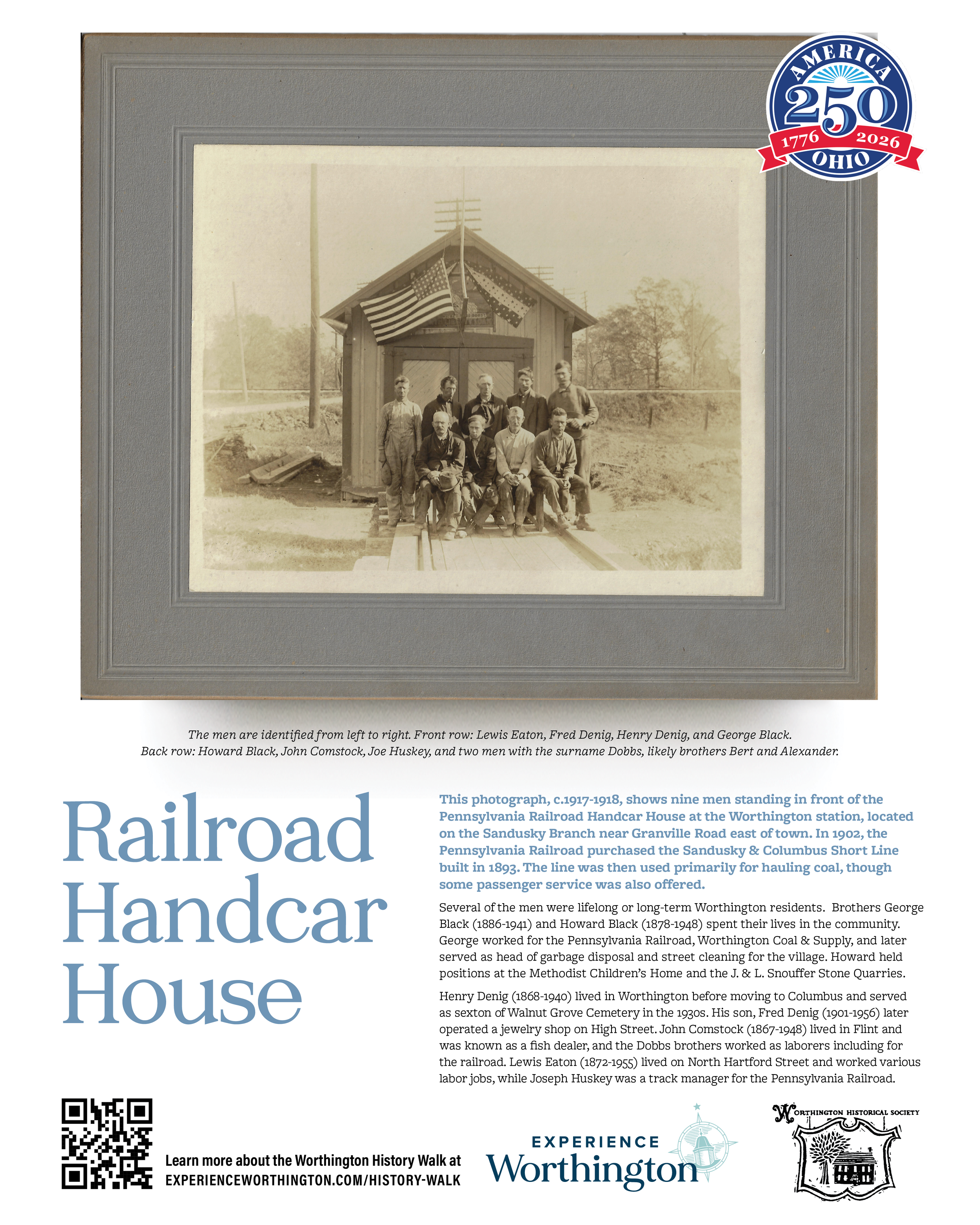
Railroad Handcar House
This photograph, c.1917-1918, shows nine men standing in front of the Pennsylvania Railroad Handcar House at the Worthington station, located on the Sandusky Branch near Granville Road east of town. In 1902, the Pennsylvania Railroad purchased the Sandusky & Columbus Short Line built in 1893. The line was then used primarily for hauling coal, though some passenger service was also offered.
The men are identified from left to right. Back row: Howard Black, John Comstock, Joe Huskey, and two men with the surname Dobbs, likely brothers Bert and Alexander. Front row: Lewis Eaton, Fred Denig, Henry Denig, and George Black.
Several of the men were lifelong or long-term Worthington residents. Brothers George Black (1886-1941) and Howard Black (1878-1948) spent their lives in the community. George worked for the Pennsylvania Railroad, Worthington Coal & Supply, and later served as head of garbage disposal and street cleaning for the village. Howard held positions at the Methodist Children’s Home and the J. & L. Snouffer Stone Quarries.
Henry Denig (1868-1940) lived in Worthington before moving to Columbus and served as sexton of Walnut Grove Cemetery in the 1930s. His son, Fred Denig (1901-1956) later operated a jewelry shop on High Street. John Comstock (1867-1948) lived in Flint and was known as a fish dealer, and the Dobbs brothers worked as laborers including for the railroad. Lewis Eaton (1872-1955) lived on North Hartford Street and worked various labor jobs, while Joseph Huskey was a track manager for the Pennsylvania Railroad.
-
![]()
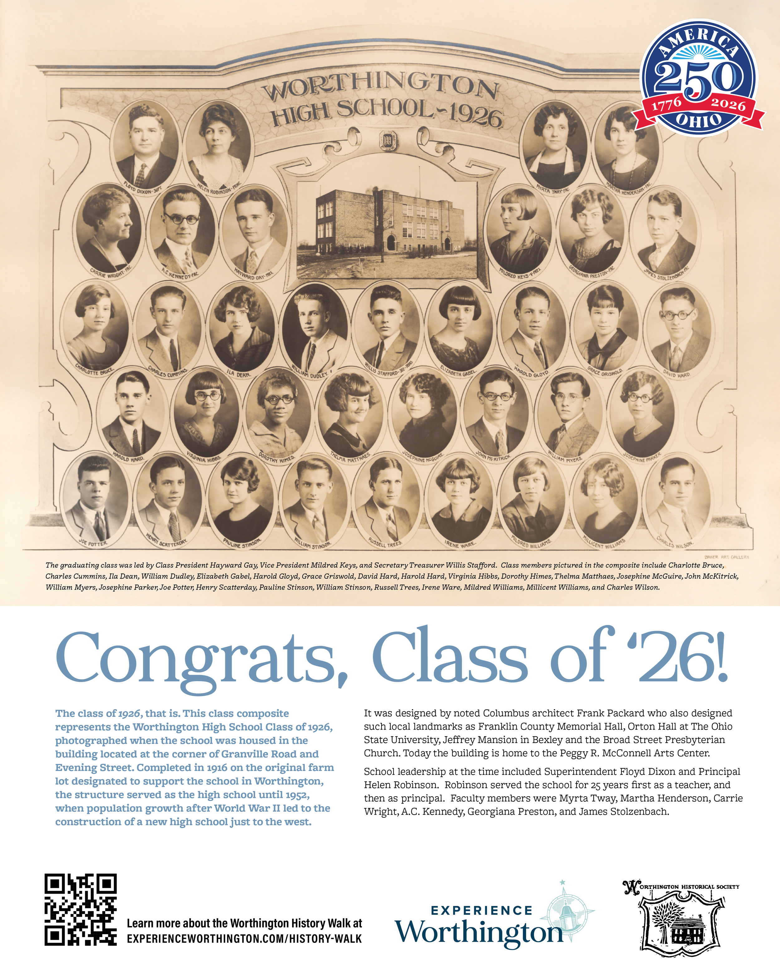
Congrats, Class of '26!
This class composite represents the Worthington High School Class of 1926, photographed when the school was housed in the building located at the corner of Granville Road and Evening Street. Completed in 1916 on the original farm lot designated to support the school in Worthington, the structure served as the high school until 1952, when population growth after World War II led to the construction of a new high school just to the west. It was designed by noted Columbus architect Frank Packard who also designed such local landmarks as Franklin County Memorial Hall, Orton Hall at The Ohio State University, Jeffrey Mansion in Bexley and the Broad Street Presbyterian Church. Today the building is home to the Peggy R. McConnell Arts Center.
School leadership at the time included Superintendent Floyd Dixon and Principal Helen Robinson. Robinson served the school for 25 years first as a teacher, and then as principal. Faculty members were Myrta Tway, Martha Henderson, Carrie Wright, A.C. Kennedy, Georgiana Preston, and James Stolzenbach.
The graduating class was led by Class President Hayward Gay, Vice President Mildred Keys, and Secretary Treasurer Willis Stafford. Class members pictured in the composite include Charlotte Bruce, Charles Cummins, Ila Dean, William Dudley, Elizabeth Gabel, Harold Gloyd, Grace Griswold, David Hard, Harold Hard, Virginia Hibbs, Dorothy Himes, Thelma Matthaes, Josephine McGuire, John McKitrick, William Myers, Josephine Parker, Joe Potter, Henry Scatterday, Pauline Stinson, William Stinson, Russell Trees, Irene Ware, Mildred Williams, Millicent Williams, and Charles Wilson.
-
![]()
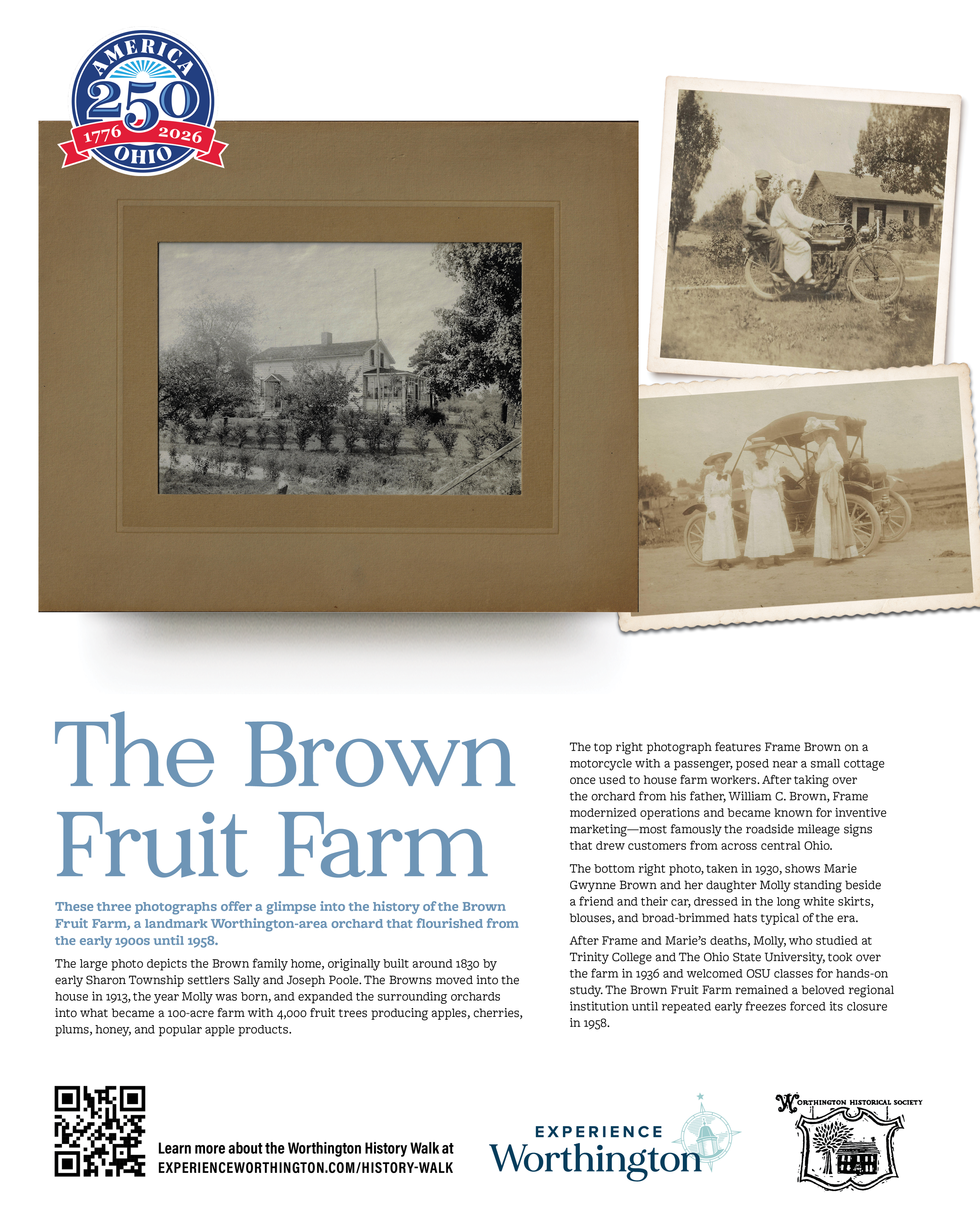
The Brown Fruit Farm
These three photographs offer a glimpse into the history of the Brown Fruit Farm, a landmark Worthington‑area orchard that flourished from the early 1900s until 1958. The first image, taken in 1930, shows Marie Gwynne Brown and her daughter Molly standing beside a friend and their car, dressed in the long white skirts, blouses, and broad‑brimmed hats typical of the era.
The second photograph features Frame Brown on a motorcycle with a passenger, posed near a small cottage once used to house farm workers. After taking over the orchard from his father, William C. Brown, Frame modernized operations and became known for inventive marketing—most famously the roadside mileage signs that drew customers from across central Ohio.
The final image depicts the Brown family home, originally built around 1830 by early Sharon Township settlers Sally and Joseph Poole. The Browns moved into the house in 1913, the year Molly was born, and expanded the surrounding orchards into what became a 100‑acre farm with 4,000 fruit trees producing apples, cherries, plums, honey, and popular apple products.
After Frame and Marie’s deaths, Molly, who studied at Trinity College and The Ohio State University, took over the farm in 1936 and welcomed OSU classes for hands‑on study. The Brown Fruit Farm remained a beloved regional institution until repeated early freezes forced its closure in 1958.
-
![]()
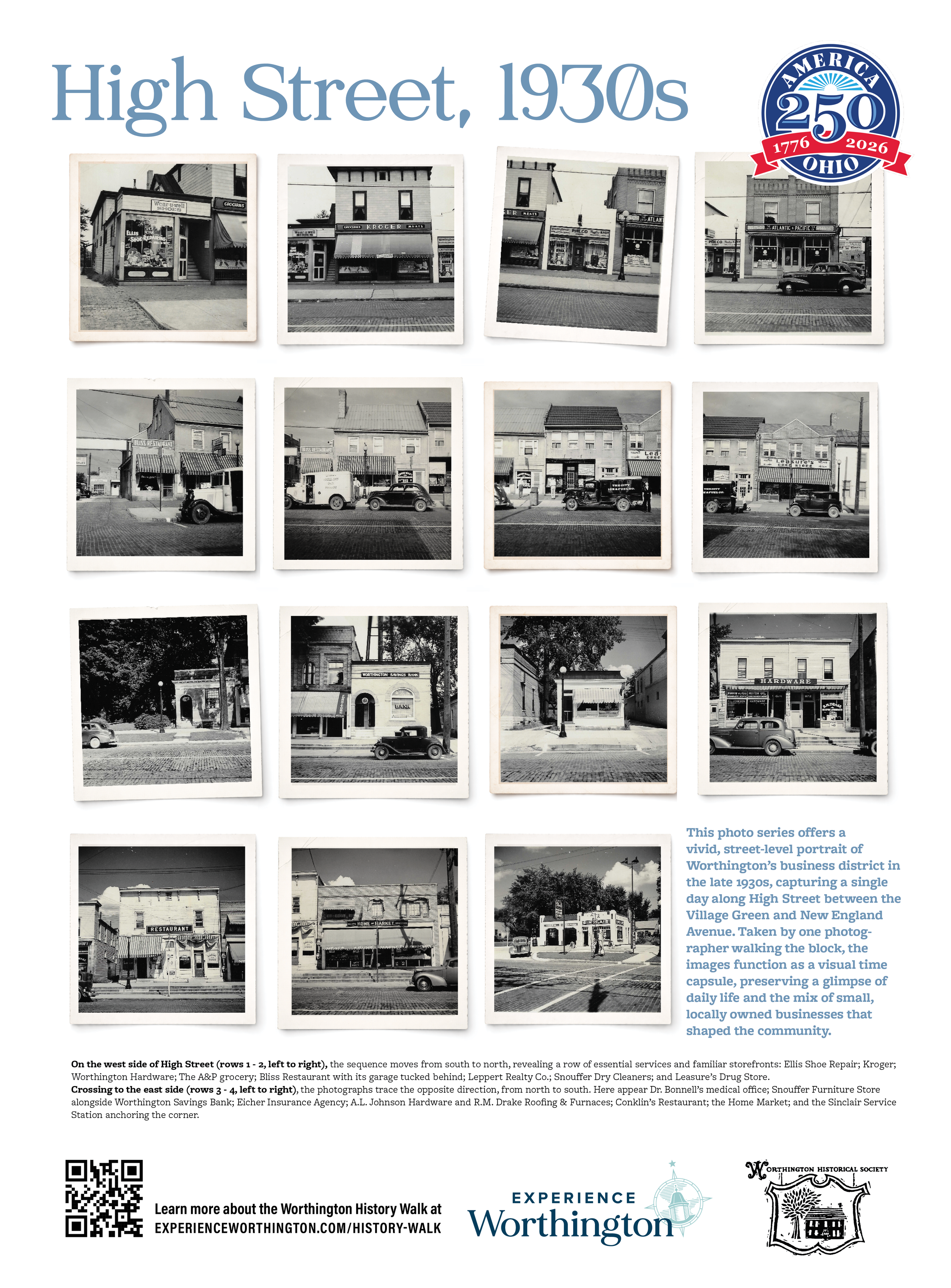
High Street, 1930s
This photo series offers a vivid, street‑level portrait of Worthington’s business district in the late 1930s, capturing a single day along High Street between the Village Green and New England Avenue. Taken by one photographer walking the block, the images function as a visual time capsule, preserving a glimpse of daily life and the mix of small, locally owned businesses that shaped the community.
On the west side of High Street (rows 1 - 3, left to right), the sequence moves from south to north, revealing a row of essential services and familiar storefronts: Ellis Shoe Repair; Kroger; Worthington Hardware; The A&P grocery; Bliss Restaurant with its garage tucked behind; Leppert Realty Co.; Snouffer Dry Cleaners; Leasure’s Drug Store; and S.E. Corbin & Son, Funeral Directors and Ambulance Service.
Crossing to the east side (rows 4 - 5, left to right), the photographs trace the opposite direction, from north to south. Here appear Dr. Bonnell’s medical office; Snouffer Furniture Store alongside Worthington Savings Bank; Eicher Insurance Agency; A.L. Johnson Hardware and R.M. Drake Roofing & Furnaces; Conklin’s Restaurant; the Home Market; and the Sinclair Service Station anchoring the corner.
-
![]()
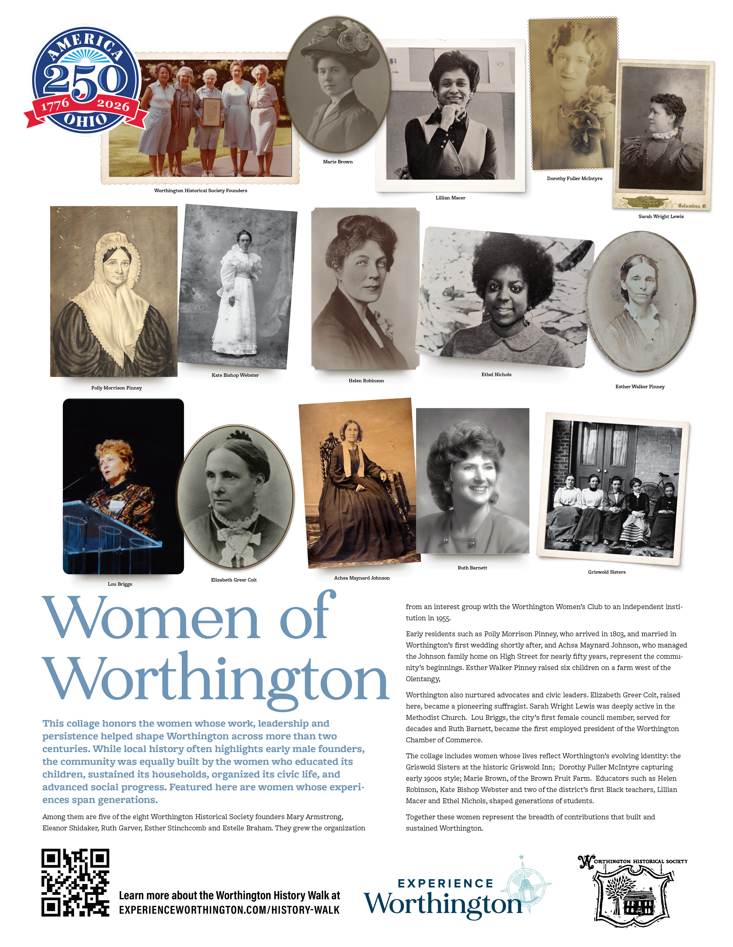
Women of Worthington
This collage honors the women whose work, leadership and persistence helped shape Worthington across more than two centuries. While local history often highlights early male founders, the community was equally built by the women who educated its children, sustained its households, organized its civic life, and advanced social progress.
Featured here are women whose experiences span generations.
Among them are five of the eight Worthington Historical Society founders Mary Armstrong, Eleanor Shidaker, Ruth Garver, Esther Stinchcomb and Estelle Braham. They grew the organization from an interest group with the Worthington Women’s Club to an independent institution in 1955.
Early residents such as Polly Morrison Pinney, who arrived in 1803, and married in Worthington’s first wedding shortly after, and Achsa Maynard Johnson, who managed the Johnson family home on High Street for nearly fifty years, represent the community’s beginnings. Esther Walker Pinney raised six children on a farm west of the Olentangy,
Worthington also nurtured advocates and civic leaders. Elizabeth Greer Coit, raised here, became a pioneering suffragist. Sarah Wright Lewis was deeply active in the Methodist Church. Lou Briggs, the city’s first female council member, served for decades and Ruth Barnett, became the first employed president of the Worthington Chamber of Commerce.
The collage includes women whose lives reflect Worthington’s evolving identity: the Griswold Sisters at the historic Griswold Inn; Dorothy Fuller McIntyre capturing early 1900s style; Marie Brown, of the Brown Fruit Farm. Educators such as Helen Robinson, Kate Bishop Webster and two of the district’s first Black teachers, Lillian Macer and Ethel Nichols, shaped generations of students.
Together these women represent the breadth of contributions that built and sustained Worthington.
-
![]()
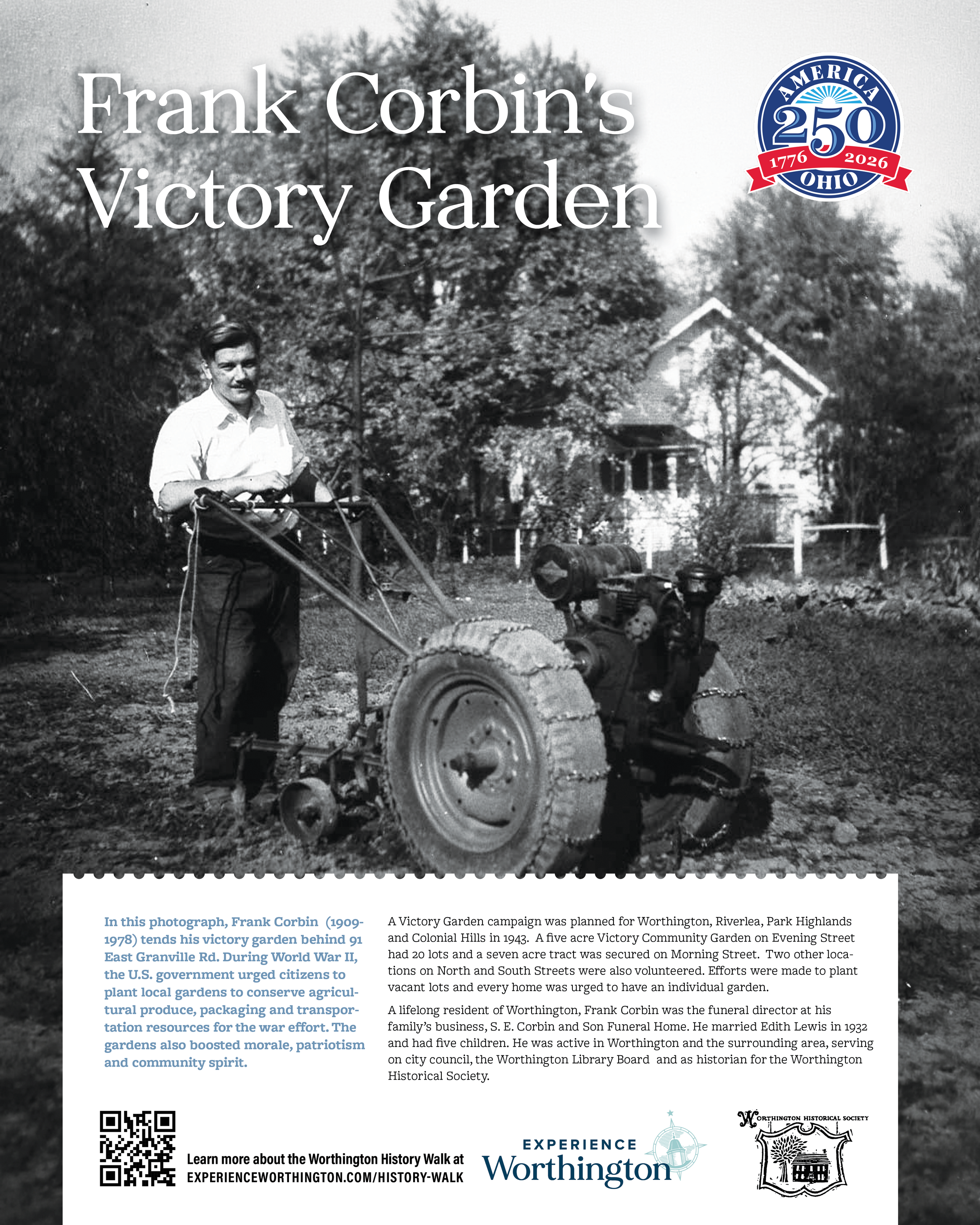
Frank Corbin's Victory Garden
In this photograph, Frank Corbin (1909-1978) tends his victory garden behind 91 East Granville Rd. During World War II, the U.S. government urged citizens to plant local gardens to conserve agricultural produce, packaging and transportation resources for the war effort. The gardens also boosted morale, patriotism and community spirit. A Victory Garden campaign was planned for Worthington, Riverlea, Park Highlands and Colonial Hills in 1943. A five acre Victory Community Garden on Evening Street had 20 lots and a seven acre tract was secured on Morning Street. Two other locations on North and South Streets were also volunteered. Efforts were made to plant vacant lots and every home was urged to have an individual garden.
A lifelong resident of Worthington, Frank Corbin was the funeral director at his family’s business, S. E. Corbin and Son Funeral Home. He married Edith Lewis in 1932 and had five children. He was active in Worthington and the surrounding area, serving on city council, the Worthington Library Board and as historian for the Worthington Historical Society.
-
![]()
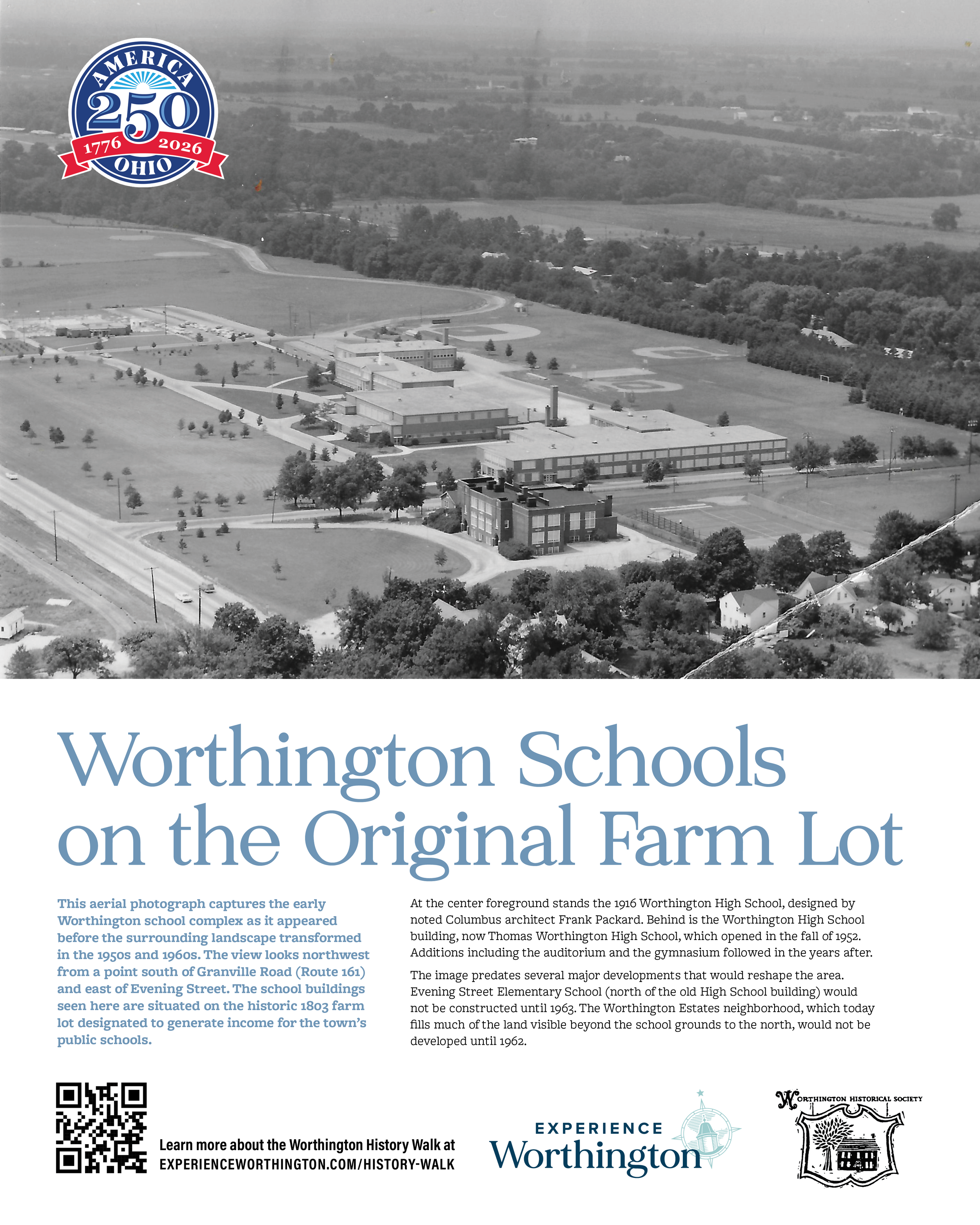
Worthington Schools on the Original Farm Lot
This aerial photograph captures the early Worthington school complex as it appeared before the surrounding landscape transformed in the 1950s and 1960s. The view looks northwest from a point south of Granville Road (Route 161) and east of Evening Street. The school buildings seen here are situated on the historic 1803 farm lot designated to generate income for the town’s public schools.
At the center foreground stands the 1916 Worthington High School, designed by noted Columbus architect Frank Packard. Behind is the Worthington High School building, now Thomas Worthington High School, which opened in the fall of 1952. Additions including the auditorium and the gymnasium followed in the years after.
The image predates several major developments that would reshape the area. Evening Street Elementary School (north of the old High School building) would not be constructed until 1963. The Worthington Estates neighborhood, which today fills much of the land visible beyond the school grounds to the north, would not be developed until 1962.
-
![]()
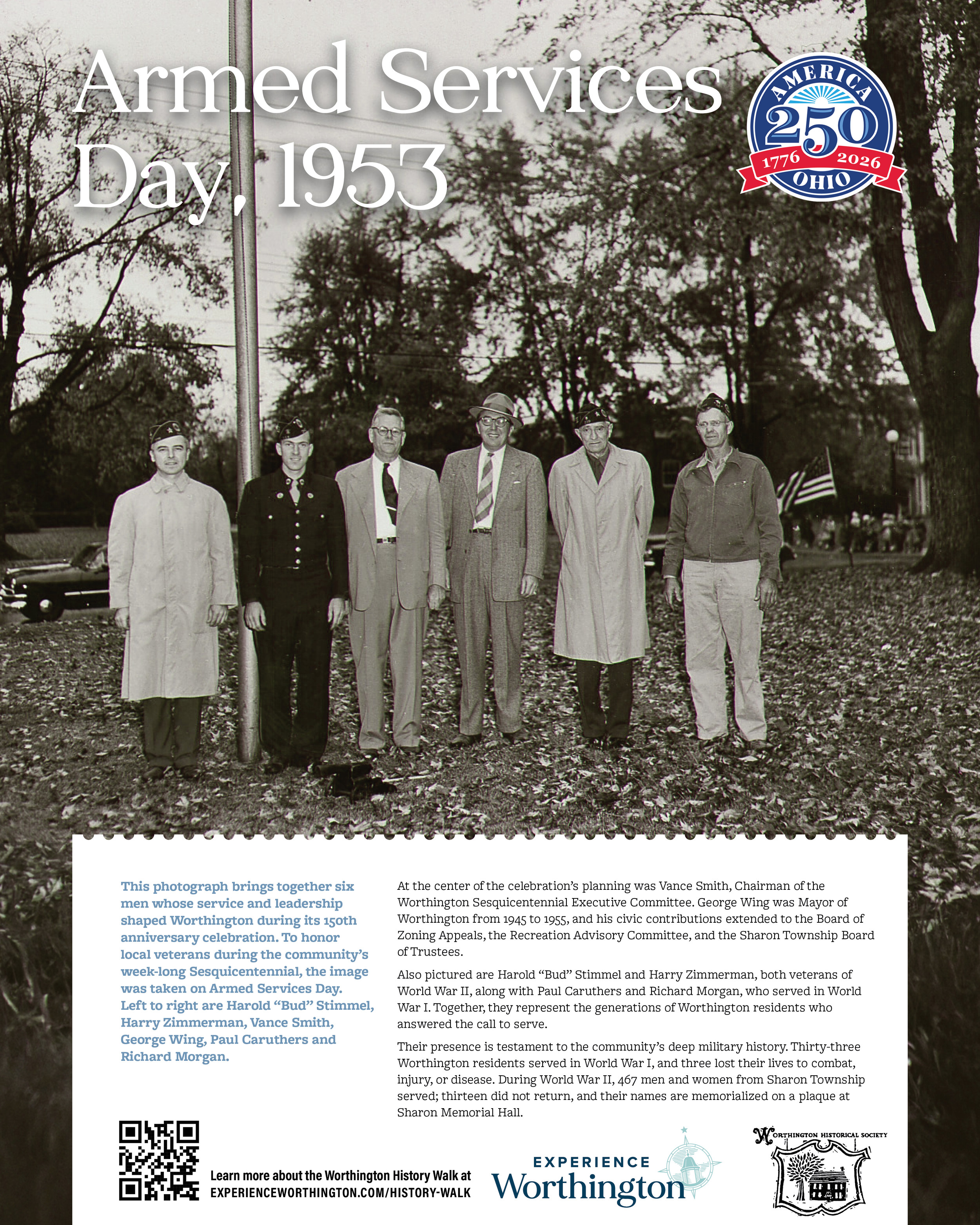
Armed Services Day, 1953
This photograph brings together six men whose service and leadership shaped Worthington during its 150th anniversary celebration. To honor local veterans during the community’s week‑long Sesquicentennial, the image was taken on Armed Services Day. Left to right are Harold “Bud” Stimmel, Harry Zimmerman, Vance Smith, George Wing, Paul Caruthers and Richard Morgan.
At the center of the celebration’s planning was Vance Smith, Chairman of the Worthington Sesquicentennial Executive Committee. George Wing was Mayor of Worthington from 1945 to 1955, and his civic contributions extended to the Board of Zoning Appeals, the Recreation Advisory Committee, and the Sharon Township Board of Trustees.
Also pictured are Harold “Bud” Stimmel and Harry Zimmerman, both veterans of World War II, along with Paul Caruthers and Richard Morgan, who served in World War I. Together, they represent the generations of Worthington residents who answered the call to serve.
Their presence is testament to the community’s deep military history. Thirty‑three Worthington residents served in World War I, and three lost their lives to combat, injury, or disease. During World War II, 467 men and women from Sharon Township served; thirteen did not return, and their names are memorialized on a plaque at Sharon Memorial Hall.
-
![]()
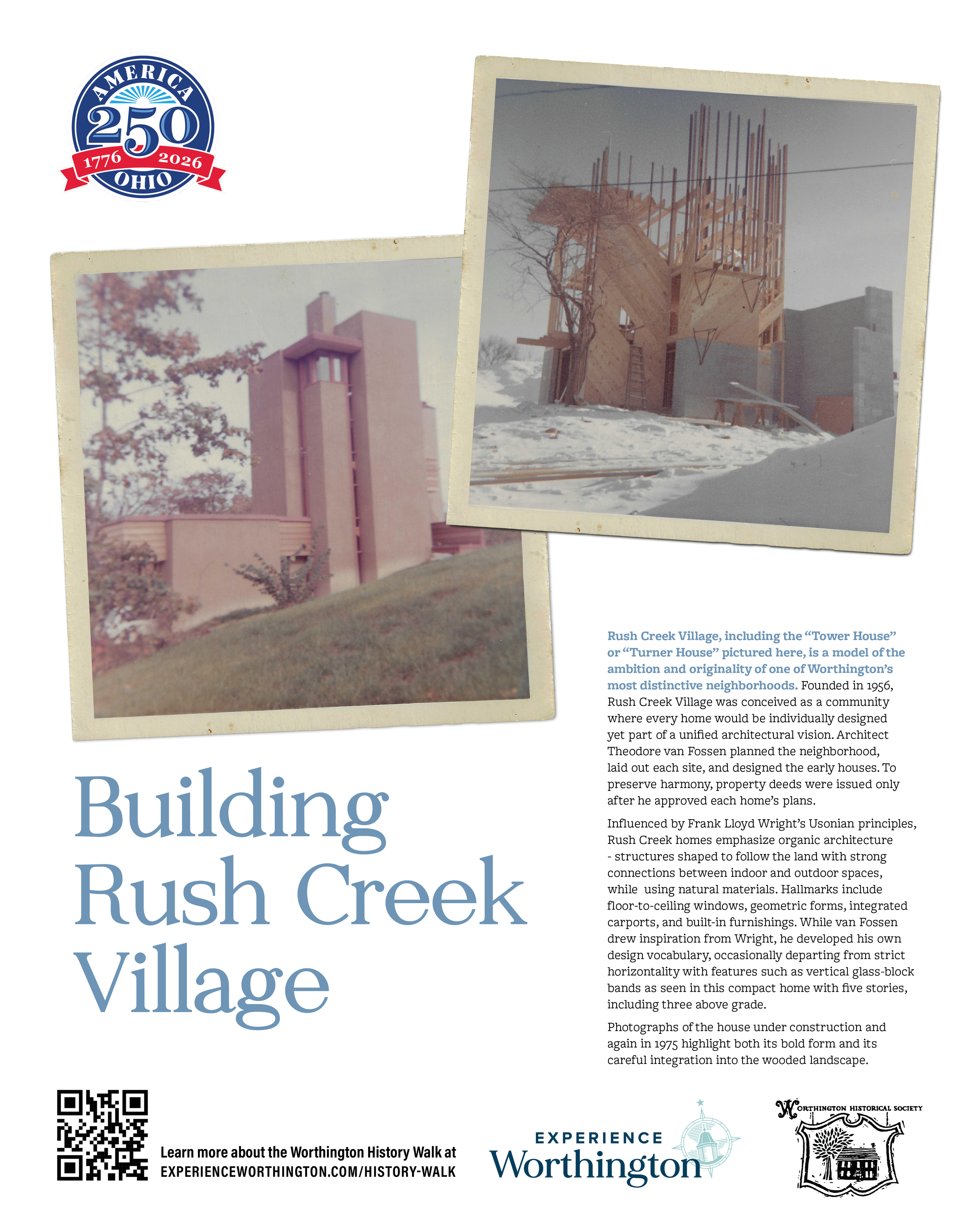
Building Rush Creek Village
Rush Creek Village, including the “Tower House” or “Turner House” pictured here, is a model of the ambition and originality of one of Worthington’s most distinctive neighborhoods. Founded in 1956, Rush Creek Village was conceived as a community where every home would be individually designed yet part of a unified architectural vision. Architect Theodore van Fossen planned the neighborhood, laid out each site, and designed the early houses. To preserve harmony, property deeds were issued only after he approved each home’s plans.
Influenced by Frank Lloyd Wright’s Usonian principles, Rush Creek homes emphasize organic architecture - structures shaped to follow the land with strong connections between indoor and outdoor spaces, while using natural materials. Hallmarks include floor‑to‑ceiling windows, geometric forms, integrated carports, and built-in furnishings. While van Fossen drew inspiration from Wright, he developed his own design vocabulary, occasionally departing from strict horizontality with features such as vertical glass‑block bands as seen in this compact home with five stories, including three above grade.
Photographs of the house under construction and again in 1975 highlight both its bold form and its careful integration into the wooded landscape.
-
![]()
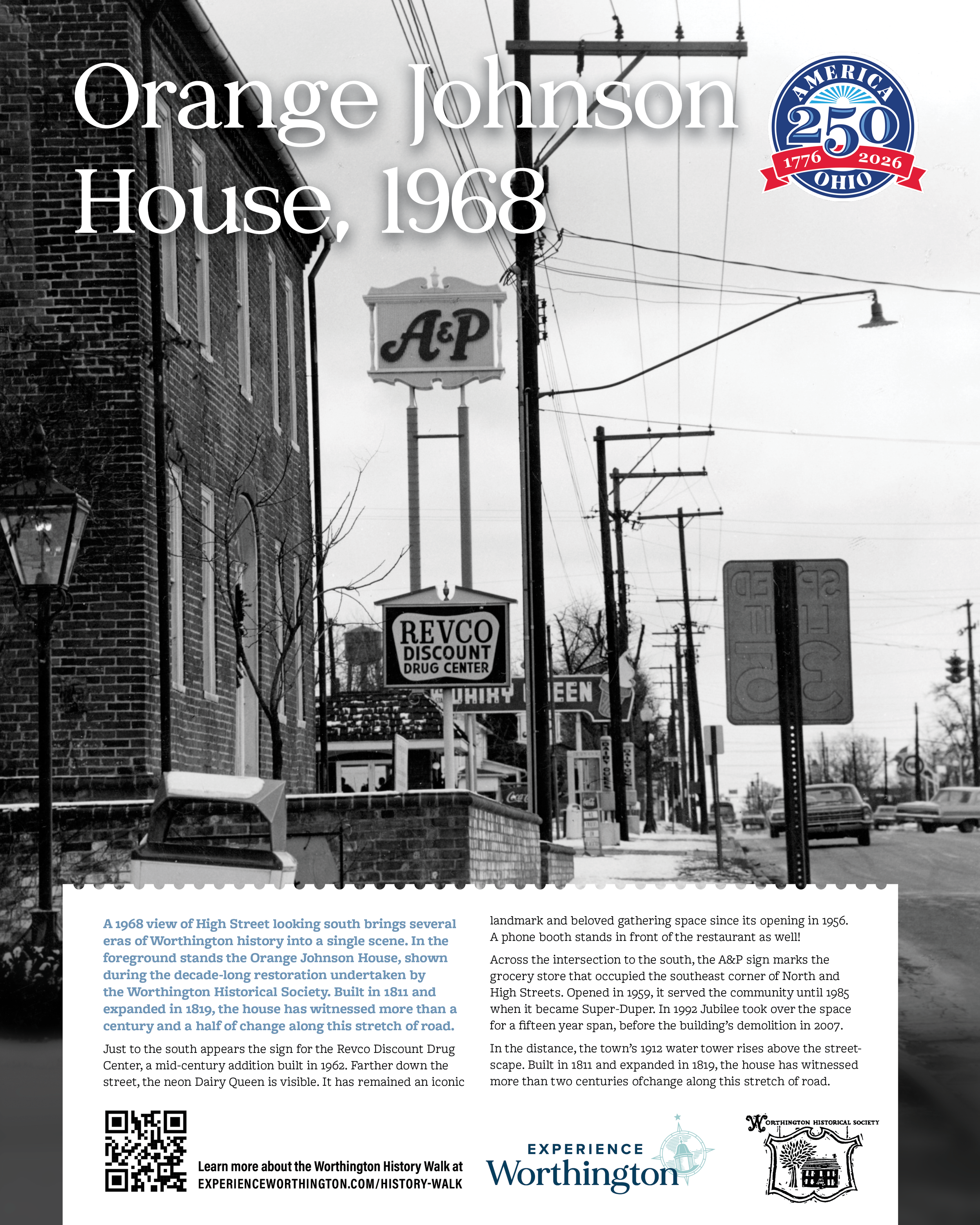
Orange Johnson House Facade, 1968
A 1968 view of High Street looking south brings several eras of Worthington history into a single scene. In the foreground stands the Orange Johnson House, shown during the decade-long restoration undertaken by the Worthington Historical Society. Built in 1811 and expanded in 1819, the house has witnessed more than a century and a half of change along this stretch of road.
Just to the south appears the sign for the Revco Discount Drug Center, a mid‑century addition built in 1962. Farther down the street, the neon Dairy Queen is visible. It has remained an iconic landmark and beloved gathering space since its opening in 1956. A phone booth stands in front of the restaurant as well!
Across the intersection to the south, the A&P sign marks the grocery store that occupied the southeast corner of North and High Streets. Opened in 1959, it served the community until 1985 when it became Super-Duper. In 1992 Jubilee took over the space for a fifteen year span, before the building’s demolition in 2007.
In the distance, the town’s 1912 water tower rises above the streetscape. Located east of High Street and just south of the Village Green, it was a familiar feature until its removal in 1969.